 3Liz
3LizWe are Open Source Software Editor
Since the 3Liz company creation, we endeavour to promote Open Source solutions for the constitution of the Geographic Information System (GIS) of our customers.
We actively participate in the QGIS project, contributing to:
- the QGIS source code and mainly QGIS Server including the reorganization of the QGIS Server 3 code.
- the documentation of QGIS and PyQGIS
- the French translation of interfaces and documentation
- the organization of QGIS French User Meetings since 2013
For our customers and our needs, we carry out our developments with Open Source licence.
You will find our achievements on GitHub and below a presentation of our main products.
Softwares for your Web GIS
Create Web map applications with QGIS® and Lizmap.
Lizmap allows in QGIS® Desktop to create Web map applications.
These can be simple for the publication of a map intended for the general public in order to valorise geographic information, like the demonstration map of the landuse in Narbonne or the earthquakes in Indonesia.
They can integrate functions of creation and modification of data for a collaborative creation of geographical information, as for the map of demonstration of the faunistic observations in Polynesia.
It is also possible to integrate dedicated features like the Paris by night demonstration map.
Lizmap source code is available:
- for the QGIS configuration plugin https://github.com/3liz/lizmap-plugin
- for the web client https://github.com/3liz/lizmap-web-client
We have also developed additional modules : Naturaliz, Cadastre, MapBuilder
WMS/WFS/WCS/WMTS QGIS Python Server
Py-QGIS-Server is an HTTP(S) server written in Python and based on the new QGIS 3 API which enable embedding the QGIS server functionalities.
Py-QGIS-Server allows to use genuine Qgis projects server side and access your geographical data with WMS/WFS/WCS/WMTS protocols.
The server may be run as a self-contained single service or as a proxy server with an arbitrary number of workers running remotely or locally. Independent workers connect automatically to the front-end proxy with no need of special configuration on the proxy side. Thus, this is ideal for auto-scaling configuration for use with container orchestrator as Swarm or Kubernetes.
Py-Qgis-Server is aimed at solving some real situations encountered in production environment: zero conf scalability, handle long-running request situation, auto restart...
- Py-QGIS-Server supports complex access control rules with extensible filters.
- Py-QGIS-Server supports all QGIS server plugins.
- Py-QGIS-Server is open source : https://github.com/3liz/py-qgis-server
WPS QGIS Server
Py-QGIS-WPS allows you to run QGIS processing algorithms, scripts or models from server without any modifications.
Py-QGIS-WPS is an HTTP(S) server written in Python et based on the new QGIS 3 Processing API and supports Web Processing Service standard from the Open Geospatial Consortium.
Py-QGIS-WPS features:
- Fully asynchronous: all jobs run in a non-blocking way.
- Supports complex access control rules with extensible filters in the same way as Py-QGIS-Server
- Py-QGIS-WPS is open source : https://github.com/3liz/py-qgis-wps
- Py-QGIS-WPS is available as Docker images: https://hub.docker.com/r/3liz/qgis-wps
Plugins for QGIS Desktop
Cadastre

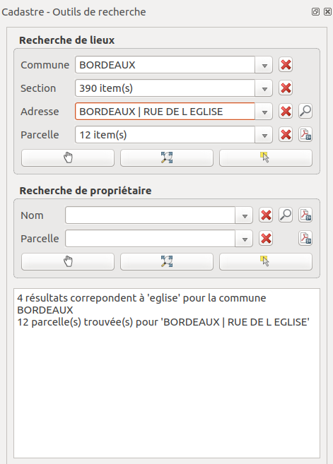
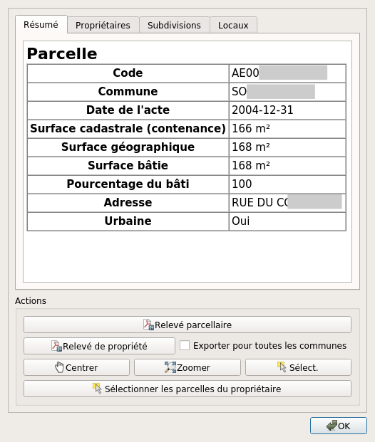
The Cadastre plugin has been designed to facilitate the use of French cadastral data in QGIS. Several modules help the user to import data, display it in QGIS, search and print reports:
- Import of French cadastral data, MAJIC and EDIGEO, into a PostgreSQL / PostGIS or Sqlite / Spatialite database.
- A loading module allows to automatically add all the cadastral layers in QGIS, with the possibility of choosing the applied style.
- A search panel offers the possibility of searching for parcels by address, owner or by situation (municipality, section) and navigating to these cadastral parcels.
- An identification tool makes it possible to display the data linked to a parcel by clicking on the polygon representing the parcel.
- Finally, it is possible to export the data in the form of parcel and property reports.

This plugin is available:
- In the list of official QGIS plugins http://plugins.qgis.org/plugins/cadastre/
- As Open Source https://github.com/3liz/QgisCadastrePlugin
The plugin documentation is also available https://github.com/3liz/QgisCadastrePlugin-documentation
Layer Board

This plugin allows you to view and modify the properties of vector and raster layers.
- View and edit layer properties
- Edit a property for multiple layers
- Perform actions on multiple layers (spatial indexes, default styles, etc.)
- Remove ghost layers
- Export layer information
This plugin is available:
- In the list of official QGIS plugins http://plugins.qgis.org/plugins/LayerBoard/
- As Open Source https://github.com/3liz/QgisLayerBoardPlugin
QuickOSM

QuickOSM lets you work quickly with OpenStreetMap data in QGIS using the Overpass API.
- Easily create queries by providing a key / value
- Choose to run the query on a zone or a range
- Configure the query: which layers, which columns…
- Open a local OSM file (.osm or .pbf) with a specific osmconf in QGIS
- Build models with the QGIS processing module
There are useful tips, such as automatic colors on the lines (if the tag is present) or actions (right click in the attribute table) for each entity (editing in JOSM for example).
This plugin is available:
- In the list of official QGIS plugins http://plugins.qgis.org/plugins/QuickOSM/
- As Open Source https://github.com/3liz/QuickOSM
Réseaux d’adduction d’eau potable et d’assainissement (RAEPA)
The French geostandard for Drinking Water Supply and Sanitation Networks (RAEPA) collects the geolocalized data necessary and sufficient for the minimum inventory of the support networks of these public services.
The data standardized by the geostandard RAEPA in each of the two areas it deals with (drinking water supply and collective sanitation) are organized as follows:
- pipes, sections of pipe made up of pipes with identical physical characteristics (diameter, material, etc.), joined at their ends; they are spatially represented by lines;
- nodes, places of junction of several sections of pipe (or piercing of a section of pipe) where structures or equipment are positioned; they are represented spatially by points;
- repairs, devices installed (on pipes or nodes) to remedy such or such network failure; they are represented spatially by points.
The RAEPA plugin makes it possible to set up an extended geostandard data structure. It offers additional attributes and values for a better description of the networks.
The plugin also offers actions on network objects:
- Network route from a pipeline
- Pipe reversal with correction of related information
- Finding valves from a pipeline
This plugin is available :
- As Open Source https://github.com/3liz/qgis-raepa-plugin
Drain Sewer Visual Inspections (DSVI)

The *European standard EN 13508-2 provides a coding system for the description of the internal condition of the drainage and sewerage networks, and of the manholes and inspection boxes, noted by visual inspection.
The DSVI plugin makes it possible to use files that comply with this standard. It offers tools for:
- Build a data model
- Import the data
- Geolocate the observations made
This plugin is available :
- As Open Source https://github.com/3liz/qgis_drain_sewer_visual_inspection
Modules for Lizmap-Web-Client
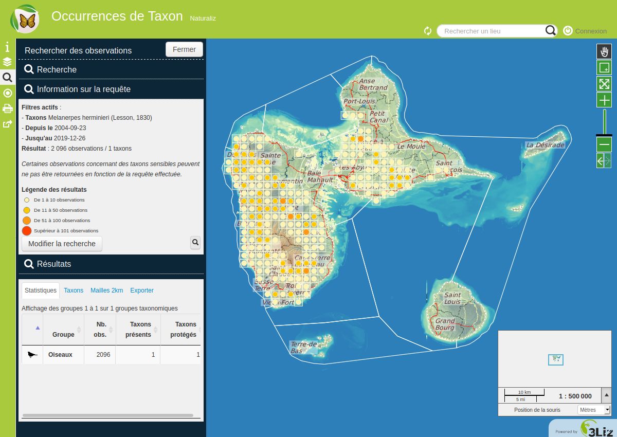
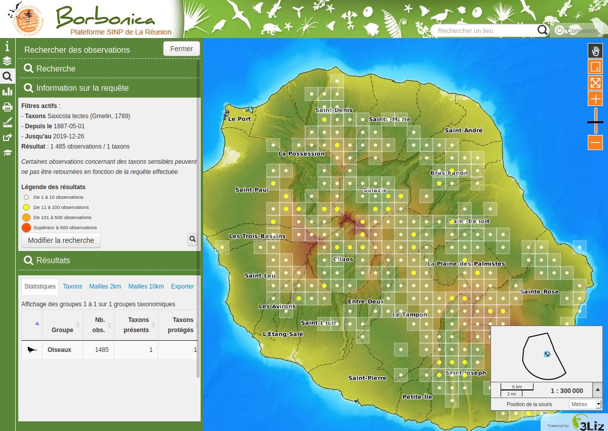
Naturaliz
The Naturaliz module was designed as part of the French Nature and Landscape Information System (SINP, french portal and french wikipedia article) for Guadeloupe National Park and Réunion National Park. It consists of several modules.
The Taxon module allows:
- storing cd_nom and cd_ref for observations,
- the search for taxa by criteria,
- full text search to find a species, etc.
The Occtax module allows:
- data management in French Occurence de Taxon format,
- export of observation data including DEE export,
- the calculation of statistics on observations
Naturaliz's main objective is to enhance observation data in the context of the SINP:
- Guadeloupe Natural Park: karunati.fr
- Réunion Natural Park: borbonica.re
This module is available:
- As Open Source https://github.com/3liz/lizmap-naturaliz-module
Cadastre
This module allows you to transform a QGIS project built with the Cadastre plugin into a web application for consulting cadastral data.
This module includes:
- an address search tool
- a search tool by parcel owner
- data export functions in the form of parcel surveys and property surveys.
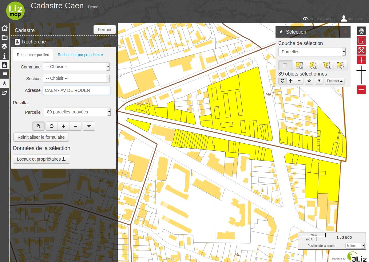
This module is available:
- As Open Source https://github.com/3liz/lizmap-cadastre-module
MapBuilder
This module allows a user to build their own maps by selecting several layers from several QGIS projects published in Lizmap Web Client and organizing them as he sees fit.
The features are:
- List of layers accessible through Lizmap according to user access rights
- Adding a layer from the listing by selecting one of the associated styles
- Layers order organization by drag and drop
- Changing the transparency of a layer
- Get information of entities according to Lizmap configurations
- Access to the attribute table according to Lizmap configurations
- PDF export of the currently constructed map
- Saving the card configuration for authenticated users
- Saving and sharing the card configuration for users who have been authorized to do so
An administration user interface is proposed and allows you to configure:
- The area displayed by default
- The available background maps
- The keys to the various known services: Geoportail, Bing, Google
- The presence or not of the tool for consulting the attribute tables of the layers
- Restriction of layers that can be used in projects in a directory
This module is available:
- As Open Source https://github.com/3liz/lizmap-mapbuilder-module
Plugins for QGIS Server
Atlas Print

This plugin adds a new service ATLAS to QGIS 3 Server which allows to export a print layout with an atlas configured, but passing an expression parameter to choose which feature is the current atlas feature.
This plugin is available :
- As Open Source https://github.com/3liz/qgis-atlasprint
WFS output extension
wfsOutputExtension is a QGIS3 Server Plugin. It extends OGC Web Feature Service capabilities. It adds Output Formats to WFS GetFeature request. It adds:
- KML
- ESRI ShapeFile as ZIP file
- MapInfo TAB as ZIP file
- MIF/MID File as ZIP file
- CSV, the datatable
- XLSX, the datatable
- ODS, the datatable
- Geopackage
Latest wfsOutputExtension versions need QGIS Server 3.0 or higher.
Retrieve wfsOutputExtension 1.0.2 version or lower if you have QGIS Server 2.
This plugin is available :
- As Open Source https://github.com/3liz/qgis-wfsOutputExtension
Qgis server plugins for infrastructure : syslog and flush project
This QGIS Server plugin provides tools for integrating QGIS Server into a network infrastructure. It allows you to monitor and manage the behavior of QGIS Server.
Syslogd: A QGIS Server filter to provide log data to syslog as JSON data for use in logstash or elasticsearch.
Flush: A QGIS Server filter to delete entries from the server configuration cache. This plugin is required if QGIS projects are accessible to QGIS Server through a mount point.
Version 1.2.0 or higher is compatible with QGIS Server 3. For QGIS Server 2, you can use the qgis2 branch or version 1.1.x and lower.
This plugin is available :
- As Open Source https://github.com/3liz/qgis-logging-plugin