How to contribute to OsmTransport ?
Par René-Luc D'Hont le mardi 28 juillet 2009, 15:41 - Système d'Information Géographique (SIG) - Lien permanent
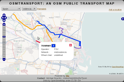
OsmTransport is a tool to display public transport network data extracted from OpenStreetMap. These data represent the bus, tram and subway lines and stops.
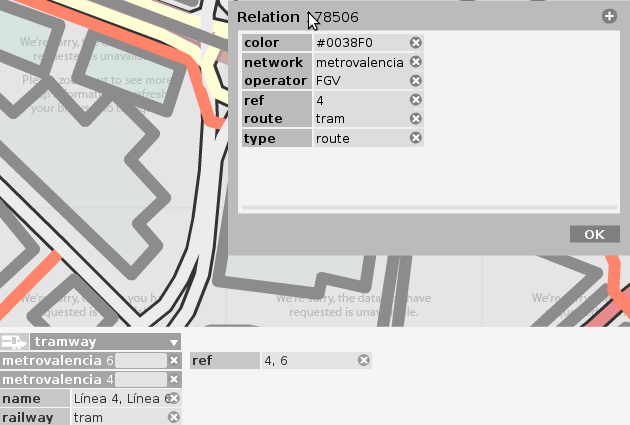
In OpenStreetMap these data are created with relations. These relations have the same tag type which is equal to route. And we use tags as described in the openstreetmap wiki http://wiki.openstreetmap.org/wiki/Relation:route#Public_Transportation.
For example the tram line 4 in Valencia, Spain is a relation with tags as follows :
- type = route
- route = tram
- ref = 4 (the number, lettre or other distinction)
- color = #0038F0 (facultative but useful)
- operator = FGV (facultative)
- network = metrovalencia (facultative)
It's possible to use Potlatch, the Flash-based OpenStreetMap Editor, to create new relation or update already done. For starting you can help to complete the tags of some lines, for example the refs of the London subway lines or the colors of the Amsterdam tram lines. For your first relation, I advise you to start with a subway or tram line.
Finally if your city isn't in OsmTramsport database, you can add a location with the link Add a location. You have to draw the extent of the network and specify the name and the country of this new location. If the country is already in the database you can immediatly see the state of the public transport network in OpenStreetMap. We update the database every morning from data made available by Geofabrik, so there may be a latency between the update in OSM and OsmTransport.
Commentaires
Do you plain to add route=rail ?
For example, it would be cool to add the parisian suburbs railway (RER).
We already think about it but we have to test it because route=rail could define international rail route like Thalys.
What spellings are supported for the colour key of the relation?
It's *color* in your example and *colour* in the English and Russian wiki.
Are both accepted?
This is a mistake, only the color tag is accepted.
<quote>This is a mistake, only the color tag is accepted.</quote>
According to the wiki, it should be "colour", not color. So, how is it?
wiki.openstreetmap.org/wi...
(Thanks for the great site:)
In the wiki, the tag was firstly name color and not colour. We decided to use color before the wiki was change, but the reason we use color and not colour, it's because in other système like CSS or SLD, the color or colour is defined by attribute color.
I don't understand what "Locations" stand for? ("Locations" is in the box you can access thanks to the '+' button, just under the line "Bus stops"). Thank you.
Locations are used to extract OpenStreetMap plublic transport informations.
Hey, great tool! I can't get it to add Georgetown Guyana though. I tried adding just Georgetown and it gave a lot of errors, then I tried Georgetown, Guyana and it did the same thing. Also the square that the buses travel in is larger than allowed so I had to draw them smaller than the routes go. Let me know if I'm doing it wrong there's a lot of visitors here that need a bus route map and there aren't ANY in the whole country. :-)
Name change required:
"Great Britain" -> "United Kingdom". I'm looking to add Belfast. "Great Britain" refers to the greater part of the UK, this specifically excludes Northern Ireland, implicitly excludes outlying islands such as the Scillies, and with a strict reading also excludes the Isle of Wight (which is already listed).
We use the same name as Geofabrik download.geofabrik.de/osm...
That doesn't make it right. There's also something up with the blog - I'm sure I've replied to this three times already.
Hello,
I would like to add transport data for Tel Aviv, Israel.
I wanted to add a new location to the map but I don't see Israel in the list of countries.
Can you please add it?
Thanks,
Amnon Khen
It's now possible to add Israel city to OSMTransport
Could you please add trolleybus routes.
You could treat them as bus routes. Just use
trolleybus as a synonym of bus.
wiki.openstreetmap.org/wi...
Many thanks! It is a really great site!