 3Liz
3LizLizmap Web Client 3.6 has landed, 3.5 still alive, 3.4 is retired
3Liz is pleased to announce the release of Lizmap Web Client 3.6, the new major version of the application.
This new version is mainly focused on the administration panel and tools for GIS technicians to help to manage their QGIS projects published on Lizmap.
This new major version means that the Lizmap Web Client 3.4 is no more maintained. However, we are still maintaining the 3.5 version.
Funders
Pre-requirements and installation
It is now required to have a minimum QGIS server 3.10. However, we recommend using the latest LTR version , i.e. version 3.22 or even the latest LTR version 3.28.
Since Lizmap Web Client 3.4, the installation of the QGIS server plugin Lizmap server was strongly recommended in
order to unlock all features.
Now, installing the plugin Lizmap server on QGIS server is mandatory. Do not forget to check your installation
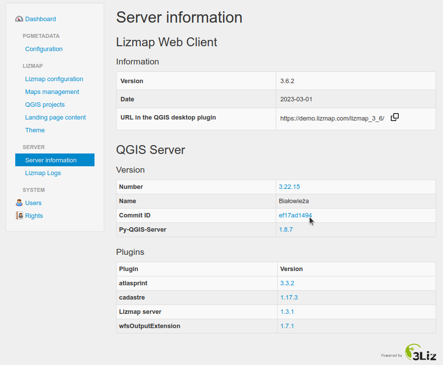
on the "Server Information" page in the administration pages and finalize it, mainly the environment variable.
Follow the instructions in your administration panel, "Server Information" page.
Even if you continue to use Lizmap Web Client 3.5, remember to install the plugin Lizmap server on QGIS server!
From now, on each new release of Lizmap Web Client, the minimum version of the plugin will be incremented. Therefore, it will be necessary for you to update it on each version.
These constraints concern the Lizmap server and are therefore the responsibility of whoever manages the server.
Administration panel
The administration interface includes the following new features:
- New rights have been added to be able to define a group of editors. This makes it easier to distinguish administrators and publishers. Publishers are the users allowed to configure and send QGIS projects to the Lizmap server. In QGIS desktop, you must provide a username that is at least an editor.
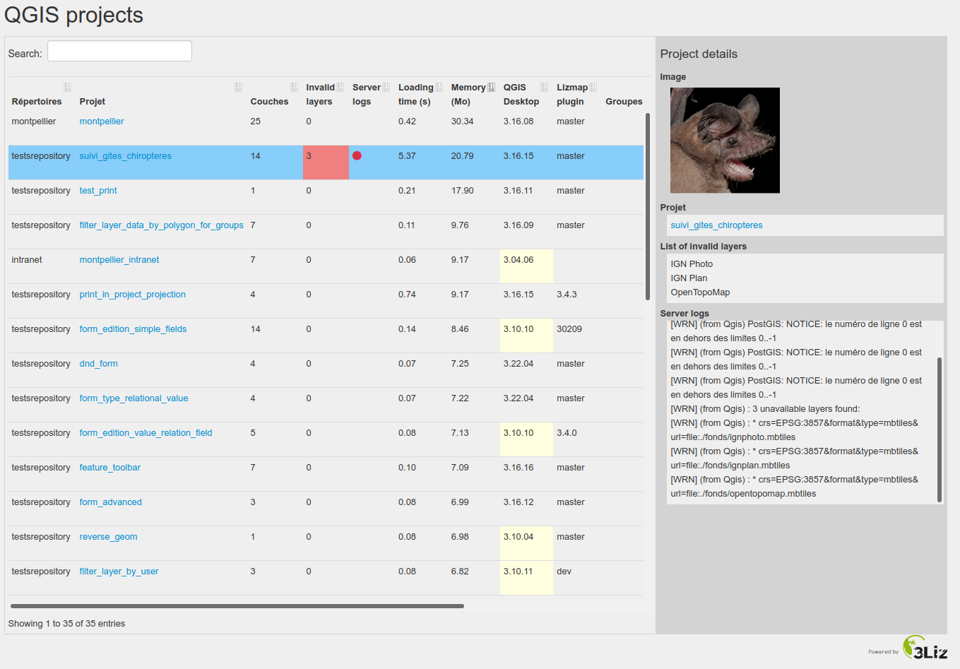
- new page showing the list of all projects in a dynamic table. In this new table you will find metadata about your projects such as the date of the last modification of the QGIS project, the version of QGIS desktop, the Lizmap plugin, etc.
More project properties are shown if the tool qgis-project-validator (available on our hosting offer
lizmap.com) is used:
- Number of invalid layers with the list of the layer names
- Memory used to load the project (in MB)
- Loading time of the project (in seconds)
- QGIS LOG file written when loading the project
This page aims to help you identify "old" projects on your Lizmap server and update them. For this, we recommend using the same QGIS desktop version as your QGIS server and installing the latest version of the Lizmap plugin available.
Very important note: QGIS projects which were designed for Lizmap Web Client 3.2 or lower will no longer be available. Remember to look at the warnings in this new page. To unlock such projects, they must be reopened in QGIS desktop with the latest version of the Lizmap plugin available in your QGIS plugin manager.
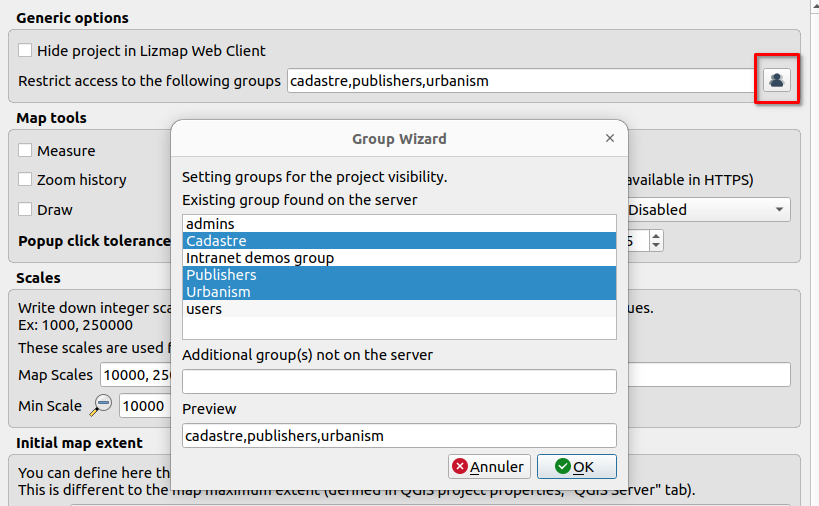
- The creation of a new Lizmap repository has been simplified. The form is now more intuitive and some rights are checked by default.
- The rights management page for groups and users has been redesigned to facilitate their management.
- The repository management page allows you to configure the CORS header (CORS presentation on MDN). They allow OGC streams (WMS, WFS) from Lizmap Web Client in other applications on other domains. It is thus possible to integrate WMS flows coming from Lizmap Web Client in an application built with mviewer.
In QGIS desktop
In QGIS Desktop, there are new configuration features:
- Enable automatic display of legend image for a layer when Lizmap starts. Pay attention to the load on your server with this option at startup.
- Activate the download of a geographic object from the popup
- Activate OpenTopoMap as a background layer
It is now possible to preview charts in the Dataviz tab.
It is also possible to get the list of the groups configured in Lizmap Web Client administration pages to correctly manage the restrictions at the project level, or the visibility for a layer, or to define the editing capabilities of a layer.
User interface
Error message when loading a Lizmap application
Before, when Lizmap Web Client encountered errors while loading a Lizmap project, the message Service not available
appeared in the background of the loading window.
This message no longer appears. If an error occurs during the map loading, an explicit message is displayed to explain the encountered issue.
If an additional JavaScript script contains an error, then an error message is also displayed.
Displaying value labels for a feature
When opening an editing form or displaying the attribute table of a layer, the values (codes) are now replaced by their labels, like in QGIS desktop.
The field values are replaced by their labels if the field editing tool is Value relation, Relation reference
and Value map.
This configuration is done in the QGIS Layer properties window, Attributes form tab.
In the case of the Value relation and Relation reference widgets, the source layer must be published in WFS.
Editing: start drawing again
When editing an object, once the geometry has been drawn, it is now possible to erase it to start drawing a new geometry from scratch.
It is always possible to modify a drawing in the context of editing.
Zoom on an object when opening the map
New URL parameters are available to be able to zoom in on one or more objects and display their popup:
layer: Layer name in WFS and WMS servicesfilter: Layer filter to initiate the zoompopup=true: to display the popup(s) of the filter objects
The layer and filter parameters will be used for WFS and WMS type queries, so make sure
that these are well compatible with the 2 types of services.
For instance, we would like to reuse this map of Montpellier showing cadastral data with the FlatGeobuf format by providing a customized link opening the popup from Park of Peyrou.
This park has 340172000BX0079 for its unique ID in the field geo_parcelle.
Therefore, we need to add in the URL above :
layer=parcellefilter=%22geo_parcelle%22%20%3D%20%27340172000BX0079%27popup=true
It gives this final result :
For your information, we can have the value of the filter with this Javascript code :
encodeURIComponent("\"geo_parcelle\" = '340172000BX0079'")`
Download
You can download the latest zip on our releases page.
You can also check the changelog of version 3.6.0, 3.6.1 and 3.6.2.
We hope you will enjoy this new version 🦎
The 3Liz team